Tribal Government & News
Tribal contingent visits Table Rocks near Medford
By Michelle Alaimo
Smoke Signals photographer
"If they hadn't of moved us, we'd probably still be here," was a thought Tribal Council member Steve Bobb Sr. had after a tour of Table Rocks near Medford in southern Oregon on Tuesday, April 26.
Tribal Vice Chair Reyn Leno and Bobb agreed that the history of the Tribe could have been different if the Rogue River Indians were never moved from the Table Rock Indian Reservation, which was established by a treaty in 1853 and was located north of the Rogue River.
The Rogue River Indians were force marched by federal troops from that reservation to Grand Ronde in 1856. The 263-mile march is Grand Ronde's Trail of Tears and resulted in the creation the current Confederated Tribes of Grand Ronde.
Leno and Bobb are both Rogue River Indian descendants, along with Umpqua.
A contingent from Grand Ronde traveled to Table Rocks, which consists of Upper and Lower Table Rock. The group included Leno, Bobb and fellow Tribal Council members Jack Giffen Jr., Chris Mercier and Wink Soderberg, Tribal Director of Operations and Tribal member John Mercier, Tribal Attorney Rob Greene and Soderberg's wife, Kathy.
It was the first visit to the Rocks for Soderberg and John Mercier. Giffen said he has been to the Rocks many times and Bobb, Leno and Chris Mercier had visited once before in 2002 when Bobb, along with Tribal member Brent Merrill, departed from the rocks on a recreation of the Trail of Tears march.
Nine years ago, Leno was there to see Bobb off and Chris Mercier was covering it for Smoke Signals, which he worked for at the time.
Visiting the Table Rocks was something that Soderberg had been looking forward to for some time and that John Mercier had always wanted to do.
The field trip, which came about when Bureau of Land Management's Medford District representatives invited Tribal Council members on a tour after coming to Grand Ronde to meet with Tribal Council, began with a quick stop near the location of Fort Lane, which no longer exists. The fort was built to overlook the Table Rock Indian Reservation and was constructed and occupied by two companies of the 1st U.S. Dragoons, U.S. Army units, to maintain peace between settlers and Rogue River Indians.
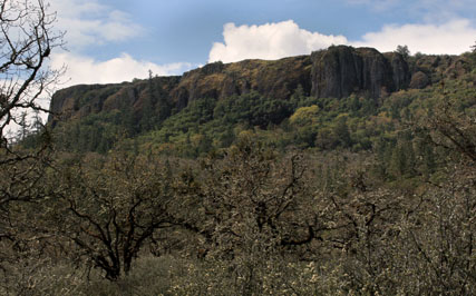
The next stop was the Lower Table Rock trailhead where the group took a walk through an oak savanna at the base of the rock. On the walk, Molly Allen, an environmental education specialist with the bureau, talked about habitat in the area, such as rattlesnakes, buck brush, lichen and various flowers. Along the trail are interpretive signs that were also pointed out and talked about.
After that, it was onto Upper Table Rock. The Table Rocks are mesas, an elevated area of land with a flat top and sides that are usually steep cliffs. Because of the flat top, vernal pools -- temporary pools that are created in the winter from the rain that then dry up in the summer months -- form on the top. This time of year the pools are still present and habitat that lives in these pools, such as fairy shrimp and tadpoles, were discussed.
After the vernal pool and more habitat talk, while still on the top of Upper Table Rock, representatives from BLM and The Nature Conservancy, who work together in the Table Rocks area, shared a map showing a number of outlined areas that are currently owned and managed by the organizations.
Then John Mercier shared a map showing the Table Rock Reservation as defined in the 1853 treaty. He interpreted a portion of the treaty to define and map out the original reservation area and Tribal GIS Coordinator Volker Mell created the map.
Before descending the Rock, a walk was taken to one of the edges to take in the view, which included Lower Table Rock. On a clear, sunny day, Mt. McLoughlin and Crater Lake can be seen from the top of the rock. Although it was a nice day with a little cloud cover, those sites were not visible.
During discussion among Tribal Council members along the way, the general consensus was that the Rogue River Indians most likely lived at the base of the rocks and near the Rogue River and are believed to have used the top of the Table Rocks for ceremony. The rocks are revered for spiritual and cultural reasons by the Grand Ronde Tribe.
Leno said he thinks that the Tribe should look into performing ceremonies once a year on the top of either rock. He also thinks that it's important for more groups from Grand Ronde, especially Elders, to visit the Table Rocks.
Chris Mercier said it is always interesting to see an area where ancestors roamed and he tried to imagine what the area looked liked pre-settlement, while Leno was thinking about how many of his ancestors walked there.
And for John Mercier, it was a very personal experience; his great-great-grandmother, Martha Jane Sands, made the Trail of Tears walk.
John Mercier said he could not thank BLM enough for the invitation to Table Rocks and every member of the Grand Ronde contingent said they thought it was a great trip and had a good time, and said they are likely to make another trip to the site.